mammatus clouds

Mammatus are pouch-like cloud structures and a rare example of clouds in sinking air.Sometimes very ominous in appearance, mammatus clouds are harmless and do not mean that a tornado is about to form; a commonly held misconception. In fact, mammatus are usually seen after the worst of a thunderstorm has passed.As updrafts carry precipitation enriched air to the cloud top, upward momentum is lost and the air begins to spread out horizontally, becoming a part of the anvil cloud. Because of its high concentration of precipitation particles(ice crystals and water), the saturated air is heavier than the surrounding air and sinks back towards the Earth.The temperature of the subsiding air increases as it descends. However, since heat energy is required to melt and evaporate the precipitation particles contained within the sinking air, the warming produced by the sinking motion is quickly used up in the evaporation of precipitation particles. If more energy is required for evaporation than is generated by the subsidence, the sinking air will be cooler than its surroundings and will continue to sink downward.The subsiding air eventually appears below the cloud base as rounded pouch-like structures called mammatus clouds.
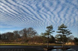
undulatus asperatus clouds
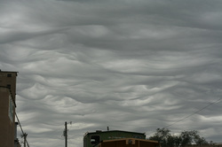
The clouds are most closely related to undulatus clouds. Although they appear dark and storm-like, they tend to dissipate without a storm forming. The ominous-looking clouds have been particularly common in the Plain States of the United States, often during the morning or midday hours following convective thunderstorm activity. As of June 2009 the Royal Meteorological Society is gathering evidence of the type of weather patterns in which undulatus asperatus clouds appear, so as to study how they form and decide whether they are distinct from other undulatus clouds.
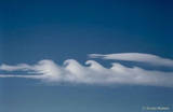
Nacreous clouds
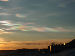
Nacreous clouds are wave clouds. They are often found downwind of mountain ranges which induce gravity waves in the lower stratosphere. Their sheet-like forms slowly undulate and stretch as the waves evolve. The clouds can also be associated with very high surface winds which may indicate the presence of, or induce, winds and waves in the stratosphere.
They form at temperatures of around minus 85ºC, colder than average lower stratosphere temperatures, and are comprised of ice particles ~10µm across. The clouds must be composed of similar sized crystals to produce the characteristic bright iridescent colours by diffraction and interference.Nacreous clouds are a type of Polar Stratospheric Cloud .
They form at temperatures of around minus 85ºC, colder than average lower stratosphere temperatures, and are comprised of ice particles ~10µm across. The clouds must be composed of similar sized crystals to produce the characteristic bright iridescent colours by diffraction and interference.Nacreous clouds are a type of Polar Stratospheric Cloud .
iridescent clouds
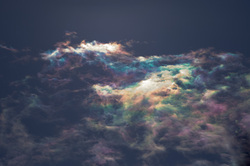
They are technically known as iridescent clouds, a relatively rare phenomenon caused by clouds of water droplets of nearly uniform size, according to a release by NASA. These clouds diffract, or bend, light in a similar manner, which separates out light into different wavelengths, or colors. Although iridescent clouds have rainbow-like colors, the way light is scattered to produce them is slightly different. Rainbows are formed by refraction and reflection. When light is refracted, it is bent by passing through mediums of different densities, such as water or a prism. Reflected light bounces off a surface at an angle equal to the angle it hit the surface at. Diffraction, though, involves light waves being scattered into a ring-like pattern.
pileus clouds
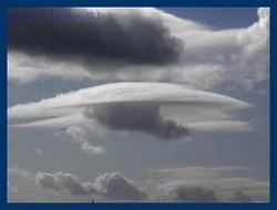
Pileus caps are made of ice crystals high in the troposphere. They form as a slab of air is shoved upward, in the shape of a dome or cap, just above a rapidly rising convective tower. Moisture in the dome condenses directly into an ice fog as the air rises and cools, forming the pileus. Next, the convection shoots right through the pileus layer. The lifted layer above the convective tower can't be too dry (must have high humidity), or the pileus cap won't develop.
billow clouds
A long narrow cloud or usu. a series of such clouds roughly parallel to each other caused by the flow of one layer of air over another producing waves at their interface the relatively cold crests of which are cloud-capped and their relatively warm troughs clear when the humidity is just right.
kelvin-helmholtz clouds
These clouds are also known as billow clouds, shear-gravity clouds, KHI clouds, or Kelvin-Helmholtz billows. The rolling eddies seen at the top of the cloud layers are usually evenly spaced and easily identifiable. The clouds are named for Lord Kelvin and Hermann von Helmholtz. These clouds are often good indicators of atmospheric instability and the presence of turbulence for aircraft.
roll clouds
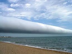
Roll clouds are relatively rare; they are completely detached from the thunderstorm base or other cloud features, thus differentiating them from the more familiar shelf clouds . Roll clouds usually appear to be "rolling" about a horizontal axis, but should not be confused with funnel clouds .
funnel clouds
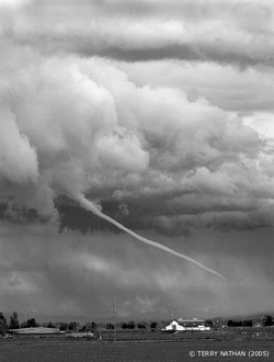
A funnel cloud is a tapered, rotating cloud created by convection and conflicting wind directions. If it reaches the surface, it becomes a tornado, or a waterspout, but only a small minority of funnel clouds become tornadoes.
Funnel clouds can also indicate weak tornadoes that don't have a visible portion reaching the ground. A destructive tornado could look like a funnel cloud if the air is unusually dry, preventing the formation of cloud material all the way to the ground. In this case, spinning debris would be the only indication of destructive winds.
Funnel clouds can also indicate weak tornadoes that don't have a visible portion reaching the ground. A destructive tornado could look like a funnel cloud if the air is unusually dry, preventing the formation of cloud material all the way to the ground. In this case, spinning debris would be the only indication of destructive winds.
contrails
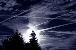
The condensation trail left behind jet aircrafts are called contrails. Contrails form when hot humid air from jet exhaust mixes with environmental air of low vapor pressure and low temperature. The mixing is a result of turbulence generated by the engine exhaust.
