Cumulus Clouds

Cumulus clouds are probably the most recognized clouds out of all of the cloud types. Cumulus clouds form below 6,000 feet, but in some extreme cases they can be in altitudes as high as 39,000 feet. They are white puffy clouds that look like cotton balls. They have a lifetime of five to forty minutes, and are known for their flat bases and lumpy outlines. Cumulus clouds appear so fluffy because bubbles of air, called thermals, linger in the cloud making it have this kind of look. Fair weather is usually associated with cumulus clouds, but they can cause short and heavy rainfall. These clouds are also partly responsible for creating cold front systems. Cumulus clouds are formed by frontal lifting or convection, which is simply the rising of warm air, which then cools and condenses to form a cumulus cloud.
Stratus Clouds

Stratus clouds are uniformed layered clouds that are below 6,000 feet. They are formed in sheets and are usually associated with overcast weather. Fog or mist is the result of very low stratus clouds. They can form only a few hundred feet above ground. They are shallow but cover a large area, and they can bring precipitation. Stratus clouds are more known for drizzle than for precipitation, however. When heavier rain falls from them, their title is changed to nimbostratus clouds. Stratus clouds are formed when a weak upward air current lifts a thin layer of air high enough to start condensation of the excess water vapor if the air temperature falls below the dew point.
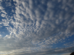
Stratocumulus clouds
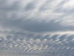
Stratocumulus clouds form in altitudes below 6,000 feet. They do not significantly change the weather, and they appear in layers, rows, or patches. A low layer of stratocumulus clouds appear near sunset and are the spreading remains of larger cumulus clouds. Precipitation does not usually fall from stratocumulus clouds even though their color may be from dark to light gray. They are different from altocumulus clouds because they are slightly larger. One neat way to determine the difference between altocumulus and stratocumulus clouds is that standing on Earth, altocumulus clouds are about the size of a human thumb nail while stratocumulus clouds are the size of a fist.
altocumulus clouds

Altocumulus clouds lie at a range from 6,000 to 20,000 feet. Altocumulus clouds are usually made of water droplets but can be composed of ice crystals at higher elevations. Parallel bands of cloud or rounded cotton balls, like in this picture, usually signify altocumulus clouds. One part of the cloud is darker than the rest of the cloud, which makes it easy for one to tell the difference between these clouds and different types of cirrus clouds. The slow uplift of warm air from a cold front pushing its way through near the ground causes altocumulus clouds to form. Thunderstorms can follow a warm and humid summer morning in the presence of this particular type of cloud.
cumulonimbus clouds

Cumulonimbus clouds are larger and are more like tall towers than regular cumulus clouds. Cumulonimbus clouds exist from near ground to 50,000 feet up in the air. The clouds can exist as individual towers of clouds, or there can be a squall line. A squall line is a line of tower cumulonimbus clouds. The tops of this type of cloud often spread out in a shape of an anvil or plume. Fast-moving convective updrafts fuel these clouds to reach such great heights, and these, like other clouds, can be made of ice crystals as their main component in cold temperatures. Sometimes the cloud can contain both liquid water droplets and ice crystals when the freezing point is in the middle of the cloud. Fair weather cumulus clouds can form into cumulonimbus clouds in the right conditions. Cumulonimbus clouds are associated with powerful thunderstorms. Snow, rain, hail, lightning, thunder, and sometimes tornadoes can accompany cumulonimbus clouds.
altostratus clouds
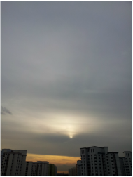
Altostratus clouds appear in altitudes of 6,000 to 20,000 feet. They are very thin and uniform, and are gray or blue-gray, creating overcast. They are translucent enough to see the sun or moon through them, however they do not allow enough light to make shadows on the Earth’s surface. Altostratus clouds are associated with coming rain, and they usually cover most, if not all, of the sky. Altostratus clouds are incapable of producing heavy precipitation, but they are often the cause of a light drizzle. Following altostratus clouds are nimbostratus clouds, which are the source of heavier precipitation.
nimbostratus clouds
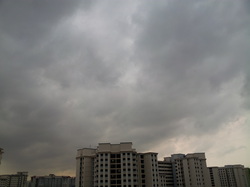
Nimbostratus clouds form at or below 6,000 feet. They are dark, low level clouds that bring light to moderately heavy prolonged precipitation, such as snow or rain. These clouds, although low in the atmosphere, may contain ice crystals when the temperatures get below the freezing point. Below nimbostratus clouds can lie broken up clouds that are called fractostratus clouds.
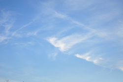
cirrus clouds
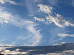
Cirrus clouds are the highest in elevation, which form above 20,000 feet. The temperature at that elevation is so cold that cirrus clouds are usually composed of ice crystals. The ice crystals are the result of the freezing of super-cooled water drops. This can only happen when the temperatures reach below –38 degrees Celsius. These high-level clouds are white, thin, feathery, and wispy in appearance. Cirrus clouds often mark the start of a warm front, which is an indication of approaching bad weather. They are the fastest moving in the atmosphere because the wind current is very strong that high up.
cirrostratus clouds
Cirrostratus clouds form in 18,000 feet and above. They are composed of ice crystals because of the low temperatures. They are sheet-like and are very transparent. They can be several thousand feet thick, and the sun and moon can still be seen through them. Sometimes the only way to tell that there are cirrostratus clouds in the atmosphere is by seeing a halo around the sun or moon. Refraction of light by the ice crystals causes the halo. Cirrostratus clouds thicken when a warm front approaches, which indicates that more ice crystals are being formed. The halo will not be able to be seen when this happens, and the sun or moon will be less visible because the clouds condense too much for clear visibility.
cirrocumulus clouds
Cirrocumulus clouds form above 18,000 feet. They are called cirrocumulus clouds because they have features of both cirrus and cumulus clouds. They usually are small white patches that look like small altocumulus clouds. Cloud ripples are associated with cirrocumulus clouds, and they are somewhat transparent. Small spaces can be seen between the clouds, and they have a puffy and patchy appearance. Sometimes they are in the sky as rows. They are composed of ice crystals, and they change slowly over time. These clouds often follow cirrus clouds in a warm front system. Therefore, cirrocumulus clouds indicate good weather.
